Car Run
Wednesday, January 08, 2014
Notice: Kansas White Way has moved to www.kswhiteway.wordpress.com
Please check out our new blog at www.kswhiteway.wordpress.com for the latest news and updates.
Wednesday, December 04, 2013
Relics of the road
So little remains, so little is known. Or has irrevocably changed, so that what we now see is either a reflection, an alteration, an overlay or something entirely different. Determining which is which depends on historical research, guesswork, luck and lots of miles along the road. We were lucky, sometimes. And sometimes we weren’t.
And, too, sometimes the relics we discovered were just that, relics, so disconnected from their context that their stories had forever faded to silence. The sign in the window at Henry Brothers Station in Goff was such a relic, long and narrow with a point facing to the right, wooden, its grain stark and sharply etched, the black blocky letters faded but still legible. Goff 18 MI.
“Where’d the sign come from?” I asked the proprietor.
She shrugged. Didn’t know, only that it was donated to the service station. Nor did she know where it would have been located, other, of course, than 18 miles from town.
It was old and weatherworn and like other relics it didn’t so much explain as merely add to the growing list of questions. How prevalent were wooden road signs? What was their average lifespan? During what decades were they used? I jotted the questions down in a pocket notebook for further research.
All we knew for certain was that we were on the original Kansas White Way, or Highway 9. Across the street stood an abandoned building that was once the White Way Chevrolet, and beyond that a remodeled Harvey House. Much of the original road has been modified and straightened for modern vehicular traffic, but towns like Goff or Netawaka or Whiting had been stops along the route so that their streets were the nearest thing to the one true path.
In between was another matter. Roads had deviated so much in past century that in places it was anyone’s guess where the original route had been laid. The highway leading west from Goff, a wide gentle curve traversing the ridgeline, had been built in the 1930s, we were told. Rumors had it that several bridges remained of the original route, and that if anyone knew where they were, it would be Gerald Swart.
Swart is the owner of Skeezix’s Toy Museum, located a mile or so west of Goff. The museum, housed in an unassuming steel building behind his house, contains hundreds of model cars, tractors, trucks, campers, construction equipment, airplanes, vintage penny banks, and historic relics from the area. Its name derives from a character in Gasoline Alley, a comic strip from the early 20th century. Near the front door, encased in glass, is an oilcoth Skeezix doll, about 18 inches tall.
We met Swart on a blustery, bitterly cold morning. After giving us a tour of the museum, he stood on the front porch and pointed into the valley below. Immediately to the south where a shallow creek snaked through the pasture was a concrete bridge, and with a little imagination one could figure out where the other two were. Even though we could see the town from our vantage, it was impossible to reconstruct the original route without adding a 90-degree bend in it somewhere. We could guesstimate, and, when I got home and pored over satellite images, could risk a guess, but in the end it was merely that—a guess—and nothing more.
Still, we followed his truck across the pasture, dropping down a hundred feet in elevation to the floor of the valley, and climbed from the warmth of the car into a teeth-numbing gale. Other than the bridges, all still showing little signs of decay or disrepair, nothing remained of the road itself other than a slight indentation in the grass. I hazarded a guess that it kept to its westward course to the northeastern edge of Corning where it then turned north. If so, it followed what is now a section line.
Subsequent research using satellite imagery and Google Earth revealed something else—a single reference that instead of heading north from Corning about five miles to branch off to Centralia, “Old Highway 9” followed what is now 52nd Rd.
It wasn’t much to go on, and it also meant that we’d have to return for further exploration. And I’m not sure that it even matters anymore, except in the context of peering through a veil to another time and era where visionaries came together to chart an organized, 365-day highway across an often-impassable, indecipherable and, for all practical purposes, uncharted wilderness known as northeast Kansas. But I think, or like to think, that as benefactors of their vision we owe them something, a nod or recognition of some sort, and what better way than to retrace their route (as much as possible) on that day in May of 1914 when they joined together to organize the Kansas White Way. So little remains except for the skeletal outline of the story, but as we all know, stories are meant to be told and retold. And if in the telling we discover something about this place where we call home, or even, if we’re fortunate, something about ourselves, then the story comes alive, part of our own mythos, our own homeground.
Thursday, November 21, 2013
KWW byway meeting arranged with KDOT, legislators
A meeting to discuss signage or byway designation for the Kansas White Way/Highway 9 has been scheduled for Tuesday, Dec. 3, 11:30 a.m., at Spring Creek Classics in Wetmore. Kansas Senator Dennis Pyle, Rep. Randy Garber and KDOT representatives will be there to answer questions concerning the steps needed to create a byway. Bob Carson is asking for representatives from towns and counties along the route to be there to show support. For more information, contact Bob at 785-866-5122.
Wednesday, November 13, 2013
Windmill on right
105.5 (leaving Blue Rapids): Turn right (west), water tower on left. 105.8: Cross railroad tracks; turn left and then right two blocks; turn west windmill on right. – Official Log of the Kansas White Way
If you want to get a feel for what early travelers faced on Kansas roads, one could do no better than take Highway 9 from the intersection of U.S. Highway 73 west of Atchison and stairstep down through Effingham, Muscotah, Whiting and Netawaka. For much of that route the proliferation of ninety-degree bends guarantees a slow and impeded drive, sure to frustrate the impatient but something of a pleasure cruise for those interested in scenery, history and the allure of the open road. The speed limit, 55 miles per hour, is rarely attainable except in a few, rare, straightaways.
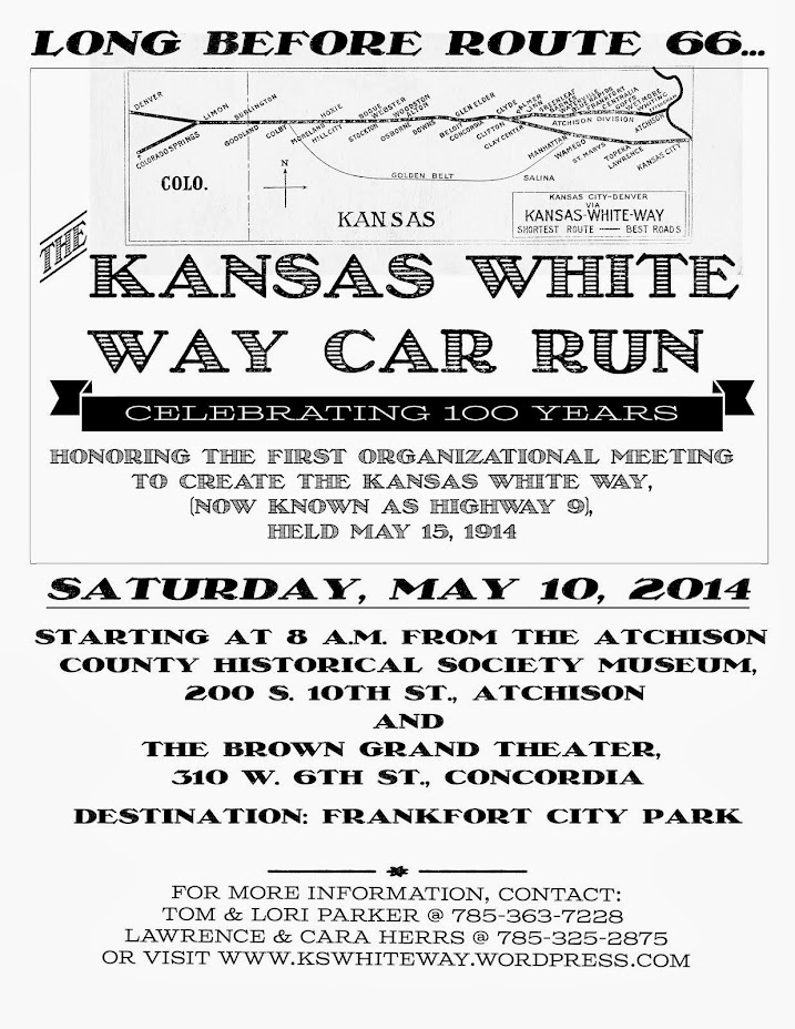
It wasn’t always so. One hundred years ago, as cars in rural areas gradually replaced horses and trains as primary means of transportation, roads were primitive at best, maps novelties and hard-packed surfaces rarer than honest politicians. But as motorized vehicles gained ascendancy, towns and counties banded together to form organizations advocating 365-day roads, otherwise known as “good” roads that didn’t dissolve into bottomless quagmires with every rain or snowstorm. One such group from Kansas City worked to create a two-pronged highway across the northern and middle sections of the state that would eventually link Chicago with Colorado Springs. It would be known as the Kansas White Way.
Meetings were often rancorous as towns bickered and fought for inclusion. Others, such as the one held in Frankfort on May 16, 1914, were enthusiastically supportive and comprehensive when an estimated crowd of 700 to 1,000 supporters descended on the town to lay out a route roughly paralleling the Central Branch Railroad. Drivers had set out from Atchison in the east and Concordia in the west, with additional drivers joining the twin convoys as they passed through the small towns dotting the course, to organize, elect leaders and designate compilers for the proposed logbook. Unfortunately for the Atchison group, their return leg was hampered by the dearth of signs, maps or experience with the area, the end result being they had to sleep in their vehicles while waiting out the night. By sunrise they must have been even more determined to get a proper highway charted through northern Kansas.
Once the highway was approved, improved and mapped, simple markings consisting of two narrow black bands enclosing a large white field were painted on fence posts, bridge railings, poles, roadside trees or other objects providing visibility. The signs were instantly recognizable by travelers and served with distinction, if not frequent reapplications of paint, until their eventual supersession by metal signs and numbered highway designations.
The course of the original Kansas White Way changed over the decades, partly through efforts to straighten roads, improve traffic flow and modernize bridges, but traces can be found in every town from Atchison to Beloit, where Highway 9 merges into U.S. Highway 24. Every town has at least one abandoned gas station, small and angled to the street with long overarching canopies sagging under the weight of time. The former White Way Garage lies shuttered beside the road in Goff across from Henry Brothers Station, a small box station that was formerly a house. Netawaka has a street named for the White Way, perhaps the last remaining visual representation. In 2006 when a car run was celebrated as a prelude to the highway’s centennial, there was one other in Frankfort, a large black and white sign denoting the White Way Chevrolet. It has since been changed to Lee Chevrolet.
So much, in fact, has been changed, or replaced, or unkinked, or simply forgotten that when organizers from four counties began planning a bigger, better celebratory car run for 2014 they were accused of advocating white supremacy. There was, though not in the way the witless detractors meant, some truth to the notion. The Log of the Kansas White Way praises the road as the “Shortest and Best Automobile Route connecting Kansas City with Denver and Colorado Springs, [passing] through the most picturesque valleys and largest cities of the state. Follow the White and Black Marker all the Way.” Long before Route 66 was a glimmer in someone’s imagination, there was the Kansas White Way. Surely, organizers say, that’s worthy of remembrance.
Plus there’s the matter of that hundredth anniversary.
“You only get one,” said Lawrence Herrs, whose auto/truck/tractor museum in Washington draws thousands annually. “We have to do it.”
Which is why I turned off the road on the eastern edge of Goff to inspect something I glimpsed in the window of Henry Brothers Station. Was it a piece of the original White Way, some unheralded and largely unknown relic? The only way to know was to stop. Slinging the camera across one shoulder, I grasped my wife’s hand as we crossed the parking lot. The adventure, I thought, starts here.
Looking for the original Kansas White Way: Goff edition
.jpg)
Gerald Swart, owner of Skeezix's Toy Museum
.jpg)
.jpg)
.jpg)
One of three original bridges on old Highway 9 west of Goff.
.jpg)
Looking east along old Highway 9; a second bridge is in the near distance.
.jpg)
.jpg)
.jpg)
.jpg)
A Skeezix doll.
Saturday, October 19, 2013
.jpg)
.jpg)
.jpg)
.jpg)
.jpg)
.jpg)
.jpg)
.jpg)
.jpg)
.jpg)
.jpg)
.jpg)
.jpg)
.jpg)
.jpg)
.jpg)
.jpg)
.jpg)
.jpg)
.jpg)
.jpg)
.jpg)
.jpg)
.jpg)
.jpg)
.jpg)
Wednesday, October 09, 2013
.jpg)
.jpg)
.jpg)
.jpg)
.jpg)
.jpg)
.jpg)
.jpg)
.jpg)
Saturday, September 21, 2013
2014 marks the 100th anniversary of the 1914 car run to organize a 200-mile stretch of the Kansas White Way
Update: Plans are now underway to hold another car run honoring the 100th anniversary of the Kansas White Way in May 2014. Tentative plans are for May 10 or May 17, both Saturdays.
This time, though, the focus has broadened to work toward a designated Kansas Scenic Byway following the White Way route. It's an ambitious goal and will require a vast amount of work not only on a community level, with representatives from each city and town on the route working in tandem, but on a legislative level, too.
We need your help! The car run will inaugurate the effort to create a scenic byway, so for now the car run will be the main emphasis of our planning. We're looking for car clubs, vintage motorcycle clubs, Cushman clubs, and anybody else who would like to be included. We intend to have two starting points, in Atchison and Concordia, though the western terminus might be shifted toward the junction of Highway 9 and 24. Frankfort remains the destination, just as it was in May 1914.
A firm date will be determined on October 4 by popular vote. If you wish to be included in the voting process, contact the administrator at 785-363-7228 or kswhiteway@gmail.com.
For more information, contact the administrator via e-mail or phone.
Subscribe to:
Posts (Atom)